High-resolution
We have now new high-resolution CMIP6 projections based on simulations supporting the recent IPCC report released in August (see AR6 Climate Change 2021: The Physical Science Basis). This was made possible thanks to the newly released ERA5-Land global reanalysis from Copernicus Climate Change Service.
- The dataset is obtained by statistically downscaling climate projections from the CMIP6 experiment using the recent ERA5-Land reanalysis, a data product extensively used around the world for historical climate analysis. A great advantage of our dataset is thus to provide an extension of the ERA5-Land reanalysis into the future.
- The dataset is global, has a spatial resolution of 0.1°x 0.1°, which makes it the the highest resolution available for CMIP6 projections.
- It comprises 5 climate models allowing to address model uncertainty and includes 2 surface daily variables: surface mean air temperature and precipitation. More variables will be added progressively. Check the Ready-to-use climate projections page for updates.
- To sample future climate uncertainty from anthropogenic forcing, two greenhouse gas emissions scenarios are available: one with mitigation policy (SSP1-2.6) and one without mitigation (SSP5-8.5). A third intermediate scenario (SSP2-4.5) will be added shortly.
These High-resolution CMIP6 projections will be used to generate climate hazards data for physical risks assessments such as rainfall triggered landslide risk and forest wildfire risk caused bu climate change.
The CMIP6 projections
The Coupled Model Intercomparison Project Phase 6 (CMIP6) is a collaborative framework designed to improve our understanding of past, present, and future climate changes. It coordinates climate model experiments conducted by various international groups. CMIP6 facilitates a more comprehensive and reliable prediction of future climate conditions by providing a platform for comparing, validating, and enhancing various climate models. It focuses on addressing key questions related to climate science, including the responses of the Earth’s climate to changes in atmospheric composition, natural climate variability, and feedback mechanisms. The project incorporates advancements in climate science and technology, offering more detailed simulations and projections. This initiative is crucial for informing climate policy and adaptation strategies, as it helps scientists and decision-makers understand the range of potential future climate outcomes and their implications. With its extensive datasets and innovative methodologies, CMIP6 serves as a vital resource in the ongoing effort to tackle climate-related challenges and enhance global climate models.
CMIP6 resolution
The HighResMIP experiment
The High Resolution Model Intercomparison Project (HighResMIP) within CMIP6 focuses on understanding the impact of increased model resolution on climate simulations. By producing high-resolution CMIP6 projections, HighResMIP aims to provide more accurate and detailed representations of climate processes and extreme weather events. High-resolution models capture small-scale features such as clouds, topography, and atmospheric and oceanic eddies more effectively, leading to improvements in simulating regional climate, extreme weather patterns, and climate variability. These models are crucial for better understanding and predicting local and regional climate impacts, which are vital for effective climate adaptation and mitigation strategies. HighResMIP’s objectives include assessing the benefits and challenges of high-resolution CMIP6 projections, understanding the influence of model resolution on climate sensitivity, and improving climate projections’ reliability. By enhancing the spatial detail of climate models, HighResMIP contributes to more nuanced and actionable climate information, aiding stakeholders in making more informed decisions in the face of climate variability and change. This initiative represents an important step forward in climate modeling, pushing the boundaries of accuracy and detail in climate predictions.
Typically, HighResMIP high-resolution CMIP6 projections have a horizontal resolution of about 25 km or less in the atmosphere and 10 km or less in the ocean. This is in contrast to more standard resolutions of approximately 100 km in the atmosphere and 50 km in the ocean seen in lower-resolution models. The exact resolution can vary among models and institutions participating in HighResMIP, as different groups may have different capabilities and focuses. The enhanced resolution significantly improves the representation of topography, coastlines, and small-scale phenomena, leading to improved simulation of local climate features, extreme events, and regional climate variability. This resolution remains coarser compared to our high-resolution cmip6 global dataset at about 10km spatial resolution which makes it the the highest resolution available for CMIP6 projections.
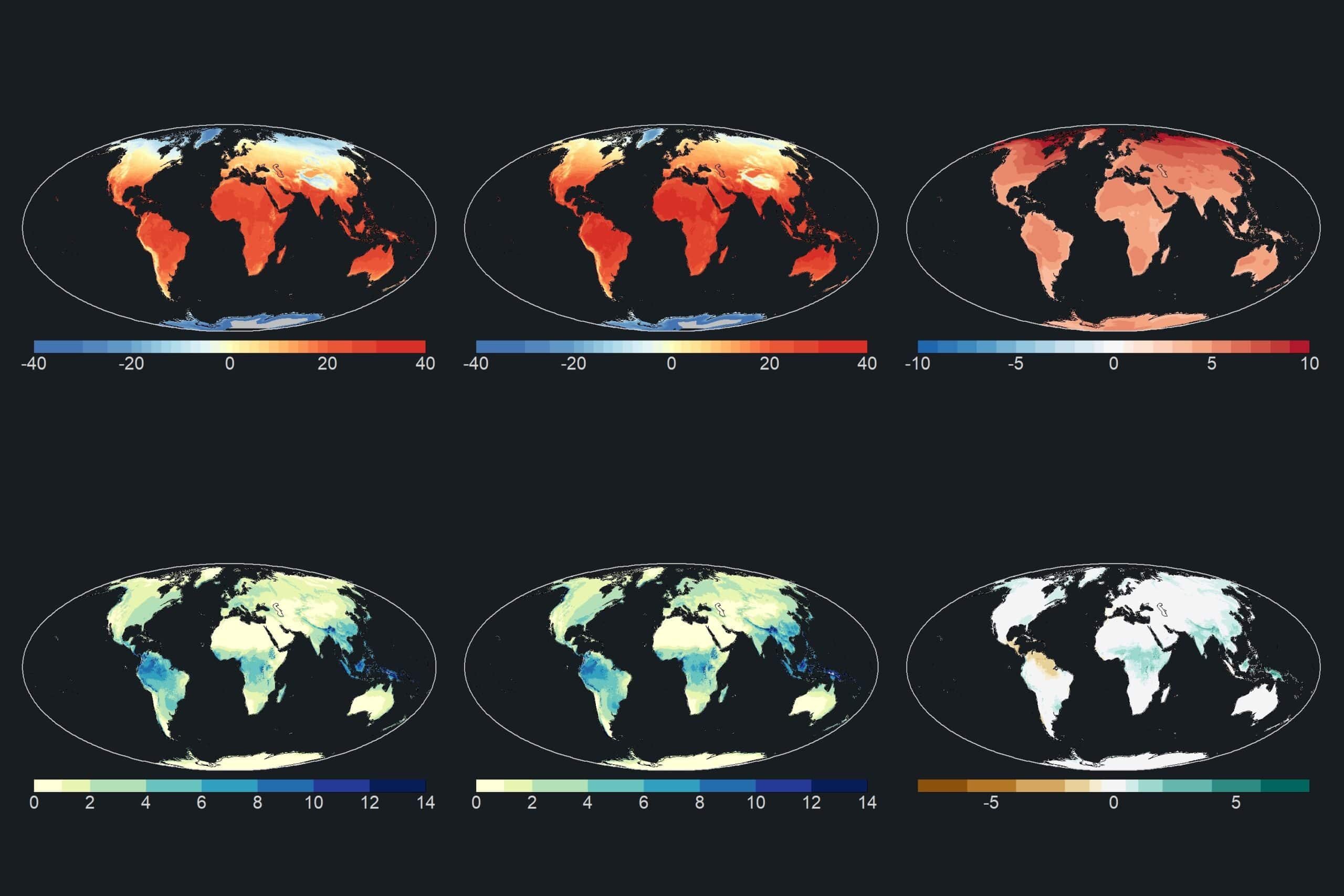
Figure. Ensemble mean averaged for present (1981-2010, left) and futur climate (2071-2100, center), and difference between the two (right) for temperature (°C) (top) and precipitation (mm/day) (bottom).