Ready-to-use climate projections

Ready-to-use climate projections data are suitable for direct use in climate change impact studies and physical risk assessments. Our referenced high-resolution, multi-model, and multi-scenarios climate projections of weather variables, indices and hazards is the most coherent collection of climate information available for local risk analysis and modeling.
Climate W3

Data specifications

High-resolution

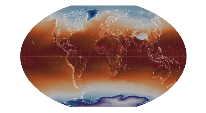
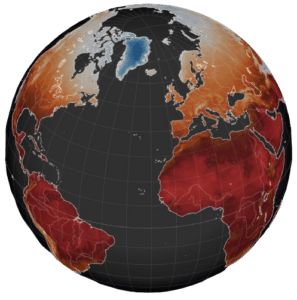
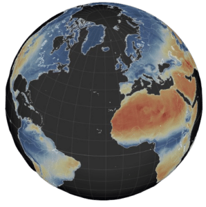
From 0.25°x0.25° (about 25x25 km) to 0.10°x0.10° (about 10x10 km) spatial resolution over the globe according to datasets and CMIP climate modelling experiments (CMIP5 and CMIP6). Temporal resolution is  daily values from 1951 to 2100.  

Read More

Multi-scenario

Three Shared Socioeconomic Pathways from IPCC AR6 (CMIP6's SSP1-2.6, SSP2-4.5 and SSP5-8.5) and 2 Representative Concentration Pathways from IPCC AR5 (CMIP5's RCP4.5 and RCP8.5). Other scenarios available on demand

Read More

Multi-model

5 reference Earth System Models for IPCC AR6 (CMIP6) and a full set of 21 models for IPCC AR5 (CMIP5). For our AR6 data update we privileged a higher spatial resolution (0.10° versus 0.25°) and more scenarios (3 versus 2) compared to our IPCC AR5 data.

Read More

Acces conditions to Ready-to-use climate projections

The climate projections datasets are available under an annual licence (special conditions for publicly funded research). Domain extractions  go by location, country or continent. 

Climate data sets

A dataset of CMIP6 high-resolution climate projections of climate indicators

Weather variables (IPCC AR6 - CMIP6)

A global dataset at 0.1° degrees resolution of 9 essential surface variables (temperature mean/max/min, total precipitation, wind speed mean/max, and relative humidity min/max) from 5 climate models under 3 SSP scenarios (SSP1-2.6, SSP2-4.5 and SSP5-8.5).
A dataset of CMIP6 high-resolution climate projections of climate indicators

Indices (IPCC AR6 - CMIP6) 

A global dataset at 0.1° degrees resolution of over 40 indices based on temperature (mean/max/min) and total precipitation from 5 climate models under 3 scenarios (SSP1-2.6, SSP2-4.5 and SSP5-8.5).
Fire weather index high-resolution CMIP6 wildfire risk

Wildfire risk (IPCC AR6 - CMIP6) 

A global dataset at 0.1° degrees resolution of Wildfire risk indicators based on the Canadian Fire Weather System from 5 climate models under 3 IPCC AR6 scenarios (SSP1-2.6, SSP2-4.5 and SSP5-8.5).
A dataset of CMIP6 high-resolution climate projections of landslide risk

Landslide risk (IPCC AR6 - CMIP6) 

A global dataset 0.1° degrees resolution of Landslide risk indicators based on NASA’s Landslide Hazard Assessment for Situational Awareness (LHASA) model from 5 climate models under 3 IPCC AR6 scenarios (SSP1-2.6, SSP2-4.5 and SSP5-8.5).
Climate projections

Storm Severity Index (IPCC AR6 and AR5 -  CMIP5/CMIP6)

A global dataset of Storm Severity Index from 5 climate models under 3 IPCC AR6 scenarios (SSP1-2.6, SSP2-4.5 and SSP5-8.5) and 4 climate models under 2 IPCC AR5 scenarios (RCP8.5 and RCP4.5) at 0.25° and 0.1° degrees resolution respectively.
High-resolution CMIP5 indicators

Weather variables - Europe (IPCC AR5 - CMIP5)

A European dataset at 0.10° degrees resolution of 6 surface variables (temperature mean/max/min, total precipitation, wind speed and solar radiation) from 21 climate models under 2 scenarios (RCP4.5 and RCP8.5).
High-resolution CMIP5 indicators

Weather variables (IPCC AR5 - CMIP5)

A global dataset at 0.25° degrees resolution of 6 essential surface variables (temperature mean/max/min, total precipitation, wind speed and solar radiation) from 21 climate models under 2 scenarios (RCP4.5 and RCP8.5).
High-resolution CMIP5 indicators

Indices (IPCC AR5 - CMIP5)

A global dataset at 0.25° degrees resolution of 40 indices based on temperature (mean/max/min) and total precipitation, from 4 climate models under 2 scenarios (RCP4.5 and RCP8.5).

Climate projections map

Explore variables and indicators  from our high-resolution climate projections datasets from IPCC AR5/CMIP5 and AR6/CMIP6 in our on-line animated interactive map. 
Ready-to-use high-resolution climate projections
Copyright ©2023 the climate data factory

Powered by Copernicus Climate Change Service